
Speedometer 55 Pro. GPS kit.
Speedometer 55 Pro. GPS kit. generates an estimated $3k–$43k/month in revenue from 2k–8k downloads/month on the App Store, according to AppCurrents estimates (updated 2026-10-02).
| Est. revenue / month | $3k–$43k |
|---|---|
| Est. downloads / month | 2k–8k |
| Estimate confidence | medium |
| Pricing | Paid $3.99 |
| Rating | 4.72 ★ (2,763 ratings) |
| Category | Navigation |
| Best chart rank | #10 Navigation Paid |
| Released | 10.06.2012 |
| App last updated | 24.09.2026 |
| Platform | iOS |
Modeled monthly estimate · rating velocity · medium confidence
About
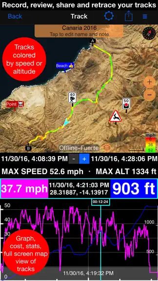
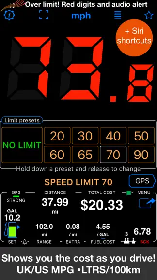
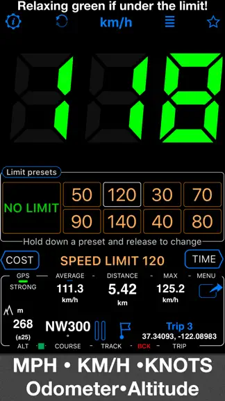
A powerful GPS speedometer, mileage tracker, and trip-cost monitor with dash-cam and action-cam video. See your speed at a glance, receive clear speed-limit alerts, record detailed routes, and understand the real cost of each trip. Features: ■ Speed Limits & Alerts Set speed limits with 4 or 8 one-tap presets. Large digits change from green to red and a sound alerts you when you exceed the selec…
Trends & analysis
Chart rank trend
US · categoryWhy it's surfacing
Scout 19Ratings & velocity
★ +0.01 in windowRating distribution
94% positive · 3k ratingsGeographic reach
best rank · 1 storefrontRevenue & downloads trend
ARPU $3In-app purchases
1 tiersUpdate history
5 updates tracked- v6.48d ago
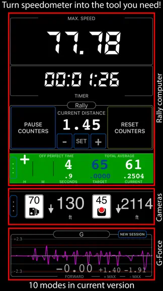
■ Rally ‣ Prepare a road book before driving the route: draw on the map, check the terrain, and generate course notes with tulip diagrams. ‣ Turn a recorded track into a road book: on the track details screen, choose More > Rally book. Course notes are generated from the road’s shape, with optional tulip diagrams, and can include the track’s linked waypoints. ‣ Keep routes editable and reuse or print your books for future drives. ‣ Follow spoken course notes in the book’s language, using your preferred available voice. ‣ When you drive a road book, the rally control panel shows the next course note with its tulip diagram and the distance to go. Set a gauge to Route map to follow the route and notes on a live map, or to Course notes to keep the next instruction in view. ■ Camera and Video ‣ Camera updates add an adjustable video light for darkness, lens selection and drag-to-zoom, focus lock with manual and per-lens focus, remembered lens and zoom, shutter delay and low-light quality, customizable viewfinder gestures, and black-screen recording. ■ Motion recording and video overlays ‣ Turn any finished track, including older ones, into overlay videos for your video editor: on the track details screen, choose More > Overlay videos > Export. Speed and Map come from the track itself, so no extra recording is needed. ‣ To add Pitch & Roll and G-Cross, open MENU > Settings > GPS Tracking > Motion and audio data and enable Include motion and audio before you record a track. No phone video is recorded, so you can pair the overlays with footage from another camera, synced by a short clap or the track audio. ‣ On tracks with motion data, choose More > View options > Map + pitch & roll + chart to scrub the chart with the map and pitch-and-roll instrument in sync. ‣ Export individual overlays from your recorded videos for use in other video projects, including transparent clips for your video editor. ‣ From a saved video, choose Export > Overlay videos to export its overlays. ■ Video transcripts and captions ‣ On iOS 26 or later, transcribe videos on-device in supported languages, search spoken words and jump to matches, correct, copy, or share transcripts, import or export SRT subtitles, and show captions during replay or in stamped exports. ■ Offline maps ‣ Download Retina-quality maps for offline use directly from Blocoware Open Street Map. Compact WebP tiles keep downloads small and save data; map detail reaches zoom 17, with house numbers visible from zoom 16. ‣ See download-size estimates and resume paused downloads without discarding what is already saved. ■ Points and photo records ‣ Everyday edits stay simple. In the point editor, open More and choose Advanced under View to compare point/photo values, resolve conflicts, and sync supported metadata. ■ A cleaner main screen ‣ We’ve removed the automatic infotainment slideshow to reduce clutter and keep your speed and map in view. Trip statistics remain available in the trip details screen.
- v6.31mo ago
■ The road, the action, and the data—all in one recording ‣ Turn the app into a dash cam for the drive or an action cam for the ride. Video, location, speed, and motion data stay together, giving every important moment the context behind it. ‣ See something worth keeping while the camera is rolling? Take a location-aware photo without stopping the recording or missing what happens next. ‣ Open saved recordings from MENU > VIDEOS and return to the exact moment you want. Use the photo shutter button during video replay to add that frame as a photo and waypoint with its location data—ready to keep, send to friends, or share on social media. ‣ In replay, swipe to move quickly or slow down for frame-level precision, and see or change the active audio output. ◆ Choose the right microphone for every recording ‣ Choose Automatic, iPhone, Any external, Wired / USB, or Bluetooth for video. The camera shows the active source, falls back safely if it disconnects, and can notify you when the microphone changes. ‣ Monitor the live microphone in headphones and keep compatible music or podcasts playing. ◆ Export ‣ Share exactly what matters: export Full video or Selected range, then choose the untouched Original or a Stamped version with your chosen data overlays. ◆ Loop recording ‣ Use loop recording when only the latest part matters, and choose how much recent video to retain. ◆ Make every recording tell more of the story ‣ Add Map · QR-Code · Watermark · Speed · Pitch & Roll · G-Cross to give each recording the context your work, activity, or journey needs. ■ Your track. Your important places. One complete story. ‣ On the track map, tap a waypoint to open, share, delete, or remove it from the track. If it has a photo, tap the preview to view and edit it. ‣ Start recording a track and keep moving. Every waypoint you create along the way stays linked to that track automatically—so gates, hazards, viewpoints, samples, photos, and notes remain part of the journey that gave them meaning. ‣ When the journey is ready to share or archive, export the track with its linked waypoints and keep the track and the places that mattered together. ◆ Terrain elevation, right on the map ‣ Move the red arrow anywhere on the map and the app now shows the terrain elevation for that exact point, next to coordinates, distance from current location, and bearing. ‣ Planning a checkpoint, trail turn, camp spot, or landing zone is easier when you can see the height of the selected place before you save it or navigate to it. ◆ Keep the map around every waypoint ‣ A map snapshot preserves the surroundings of each waypoint for quick visual reference—even after you leave the place.
- v6.22mo ago
■ Waypoint labels, your way ‣ Waypoint names can now be shown as compact or larger map labels, with either the current filled background or a clean no-background style using the waypoint color for the text. ‣ Waypoints with attached photos can show a thumbnail right above the name on the map, making photo points easier to recognize without opening the waypoint first. ‣ To set it up, open Map Settings > Common settings > Waypoint labels. Label size, Photo thumbnail, and Label background are separate visible controls.
- v6.13mo ago
■ Pitch & Roll ‣ Pitch & Roll panels now include motorcycle and airplane image options. Choose them from the panel settings. ■ Map and Track Improvements ‣ Active track line width is now configurable in Map Settings. The thinnest line is now the default for better map visibility. ‣ The purple tail is now called Location breadcrumb. It is hidden from the map menu while recording, and now starts off by default to avoid confusion. ■ Channels replace GPS Beacons ‣ Channels are the new way to share live location while tracking. Share by private web link with optional password protection, or use a shared group channel where members can follow each other in the app or on the web. ‣ Channels are off by default. Your location is shared only when you turn sharing on for an active or joined channel while track recording is running and not paused. ‣ Channels do not require an account or registration. They expire automatically after idling, and the creator can delete them at any time. ■ Voice Coach and Navigation Hints ‣ Voice Coach and navigation hints now work together in one clearer setup. Configure regular coach announcements, on-course guidance, spoken target distance and bearing, and relative or absolute spoken bearings from the same place. ‣ Voice Coach can now include target navigation guidance in regular time or distance interval announcements, telling distance and bearing to the current target when one is active. ‣ New absolute spoken bearing guidance lets you keep the iPhone in your pocket and navigate by voice hints while holding a magnetic compass in your hand. ‣ Huge thanks to Steve for suggesting absolute bearing voice guidance and testing it in the wild. ■ Fixes and Compatibility ‣ Improved KML and KMZ export/import compatibility, including more reliable fallback handling for waypoint descriptions and notes. ‣ General Sound Settings now include a new option to explicitly select which device voice is used for voice guidance and announcements. ‣ Fixed issues with the course line after returning from background, the export file name pattern editor on iOS 17, and a rare Trips & Tracks filter crash on iOS 15.
- v6.04mo ago
■ Mileage and Cost Calculator ‣ Add intermediate stops to your estimates, making them more precise and useful for cost planning, reimbursement records, and tax reporting. ■ More Natural Voice Guidance ‣ Navigation hints, voice coach announcements, and waypoint proximity alerts now use the best available voice automatically, with improved handling of plurals, decimals, numbers, and time or duration announcements across all supported languages. ■ Trip Tracks and Offline Maps ‣ Fixed track numbers not being shown on the map when viewing all tracks for a trip. Start and end markers now match the track numbers from the trip track list. ‣ Pinned tracks can now be shown on the offline map download screen, giving better spatial awareness when choosing which region to download. ■ Drawing Tools for GPS Camera and Ground Overlays ‣ GPS Camera drawing tools received a major update with text, dimension, and selection tools. ‣ The new drawing tools and options can now also be used when editing ground map image overlays. ‣ Drawings are no longer hardcoded into photos or ground image overlays on save, so they can be edited later. ■ Import Fixes ‣ Improved error handling when importing incomplete or corrupted trip archives. ‣ Fixed GPX import so the import options page closes correctly after import, and the Cancel button works as expected.
Speedometer 55 Pro. GPS kit. — FAQ
How much money does Speedometer 55 Pro. GPS kit. make?
According to AppCurrents estimates, Speedometer 55 Pro. GPS kit. generates approximately $3k–$43k per month (medium confidence), modeled from its the App Store chart performance, rating velocity, and monetization signals.
How many downloads does Speedometer 55 Pro. GPS kit. get?
Speedometer 55 Pro. GPS kit. sees an estimated 2k–8k downloads per month on the App Store, per AppCurrents modeling.
Is Speedometer 55 Pro. GPS kit. free?
Speedometer 55 Pro. GPS kit. is a paid app priced at $3.99 on the App Store.
What is Speedometer 55 Pro. GPS kit.'s rating?
Speedometer 55 Pro. GPS kit. holds a 4.72-star average from 2,763 ratings on the App Store. It currently ranks #10 on the Navigation paid chart.
When was Speedometer 55 Pro. GPS kit. released?
Speedometer 55 Pro. GPS kit. launched on the App Store on 10.06.2012. Its latest version shipped 24.09.2026.
Apps like Speedometer 55 Pro. GPS kit.
See all alternatives → Google MapsNavigation · $760k–$4.1M/mo
 Transit • Subway & Bus TimesNavigation · $690k–$3.8M/mo
 onX Hunt: GPS Hunting MapsNavigation · $350k–$1.2M/mo
 Speedometer SimpleNavigation · $48k–$260k/mo
 Trucker Path: Truck GPS & FuelNavigation · $48k–$260k/mo
 Find my Phone - Family LocatorNavigation · $37k–$210k/mo